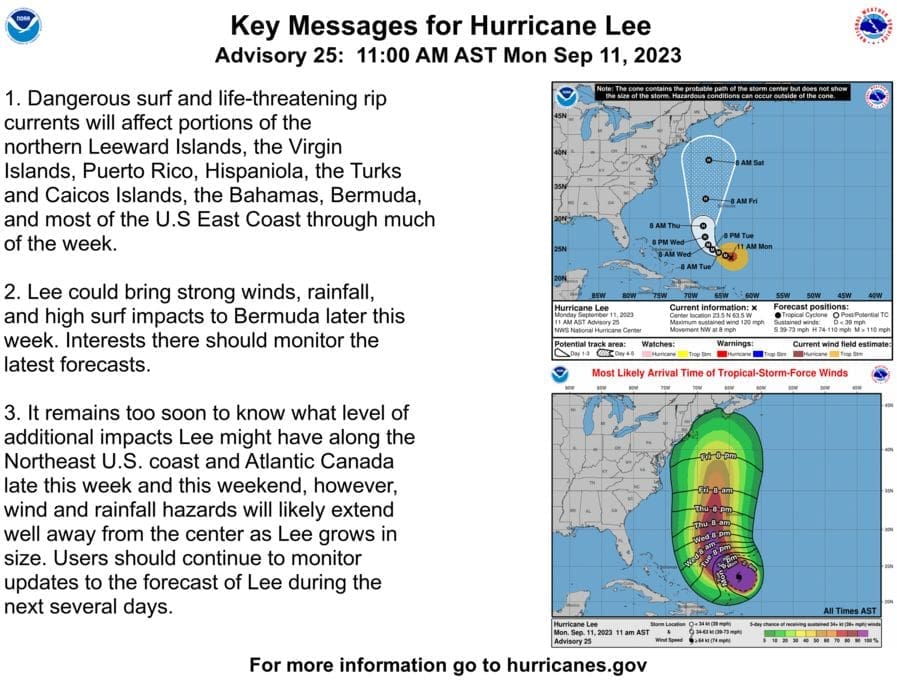
The National Weather Service in Mount Holly issued this Hurricane Lee update at 11 a.m. Monday.
The Delaware Emergency Management Agency is tracking the path of Hurricane Lee through the Atlantic but as of now sees no signs of it making land in Delaware.
“At this time, odds of tropical storm conditions anywhere in our region are only 5%, but as the storm is still several days away, all interests should closely monitor the progress of the storm,” said John Petersen, DEMA’s public information officer.
The storm will create dangerous surf and life-threatening rip currents in the region and waves as high as 10 feet by the end of the week, he said.
If the hurricane shifts further west as it nears, it could still cause gusty winds and rain over Delaware, he said.
As of now, he said, “Dangerous surf and life-threatening rip currents are the most likely hazard to affect our region. These will likely become significant Tuesday and only become more severe through the remainder of the week as the storm moves northward in the western Atlantic. They should start to subside by Sunday.”
IN THE NEWS TODAY: Delaware Military Academy remembered the horror of 9/11, heroism of helpers
Ocean waters will become increasingly hazardous for small craft starting Wednesday as seas build, Petersen said, with waves possibly exceeding 10 feet by Thursday or Friday.
DEMA is monitoring the situation and providing updates to Gov. John Carney’s office, in case he needs to activate any additional resources, such as the Delaware National Guard, a spokeswoman said.
Petersen said that those interested in the storm’s track should go to www.nhc.noaa.gov; for the latest rainfall amount forecast, go to https://www.wpc.ncep.noaa.gov/F#page=qpf; for the latest local forecast go to www.weather.gov/phi.
The next hurricane briefing will be issued by 4 p.m. Tuesday.
DEMA routinely sends out information about being ready for hurricane and storm season. Here’s what they have to say.
MAKE A PLAN:
- Know your hurricane and flood risk and take steps to prepare. Are you in an evacuation zone? Find out at preparede.org/know-your-zone. Are you in a flood zone? Use the flood planning tool at de.gov/floodrisk.
- Just because you don’t live near the coast doesn’t mean you’re not at risk. Remnants of tropical systems can bring tornadoes, extreme rainfall and life-threatening flooding to areas hundreds of miles inland from the coast. The last bits of Ida flooded huge parts of the Brandywine and downtown Wilmington.
- Know what you’ll do if a hurricane is forecast to impact your area, how to contact your family, and any community emergency plans. Check the tips at preparede.org/make-a-plan
- Declutter drains and gutters to allow water to flow.
- Check out the trees on your property and consider trimming trees and dead limbs.
- Purchase or renew a flood insurance policy. It can take up to 30 days for a policy to go into effect. Most homeowner’s policies do not cover flooding. Learn more at floodsmart.gov
- Take into account seniors and those with special needs. Learn about the DHSS Office of Preparedness and its “Preparedness Buddy” program. The University of Delaware also has resources to help plan for an emergency at: www.allreadyde.org
- Pets and Animals: The DHSS Office of Animal Welfare and Delaware Animal Response Program has resources for animals and emergencies.
- “Practice makes prepared!” Once you have a plan, go over it and make sure everyone knows what to do. Include children in your plan and help them practice it with the family. Check out the brochure “Prepare with Pedro” at ready.gov.
BUILD A KIT: preparede.org/build-a-kit
- Gather supplies for at least one week for every member of the family, including non-perishable food, water, medications, and even infant formula and diapers for small children.
- Include a first aid kit, flashlights, radios, matches in a waterproof container, and spare batteries.
- Keep a small amount of cash in a safe place in case ATMs are not working.
- Don’t forget pet supplies, including crates, extra food and water, and other items they may need.
- Keep important documents in a safe place or create password-protected digital copies. Consider using a waterproof container to store the copies.
- Have a cell phone power bank or portable car charger and try to charge phones ahead of time.
- Make sure your car’s gasoline tanks are filled and replenish propane tanks for outdoor grills.
- Consider getting a generator or other power backup source. Remember, ONLY USE a generator or other gasoline-powered machinery OUTDOORS and away from windows.
- Check on your neighbors to make sure they are safe and prepared and have supplies they need.
- Review insurance policies to make sure you are covered. Document your property in advance, including photographs, in case you need to make an insurance claim.
STAY INFORMED: preparede.org/stay-informed
- Hurricane season is also a good time to sign up for emergency alerts through the Delaware Emergency Notification System (DENS). DENS is the primary system for public warning and protective action information, allowing emergency managers to send messages down to the specific street, neighborhood, or larger areas (like Evacuation Zones) affected by the event. If there is an evacuation notice, it will be sent by text, call, email or social media, depending on user preferences.
- Download the FEMA app. You can receive weather alerts from the National Weather Service for several different locations anywhere in the United States.
- Tune to local television or radio stations to learn which areas are affected by a potential storm and if/when an evacuation warning or order has been issued for your specific zone.
- Social Media: Follow DEMA and local government sources online for the latest news and information from the State of Delaware. DEMA publishes information via social media on Facebook, Instagram, Twitter, and Next Door.

Betsy Price is a Wilmington freelance writer who has 40 years of experience, including 15 at The News Journal in Delaware.
Share this Post


